Monday, August 31, 2020

Mesa Verde National Park, CO - UNESCO World Heritage Site

 Place: Mesa Verde National Park, CO

Weather: Generally sunny, 47/78F.

Route: From Chaco Canyon 159 miles NNE on US-550 N, NM-574 N, CO-140 N, US-160 W.


Significance:
There are three UNESCO World Heritage Sites I'll be visiting in this part of the country. They share in common an advanced culture, but the places and building techniques varied. Mesa Verde is best known as where the famous cliff dwellings are located. Cliff dwellings doesn't really do them justice though - they aren't just some cave on the side of a cliff - they were huge buildings - as many as 100 rooms per dwelling.  The area also includes farming terraces, dams, and art painted on the sides of the cliffs.

Websites: UNESCO World Heritage Site, National Park Service.


Video: 


Images:


One of the larger dwellings (from usatoday.com)

This shows more of the landscape (from theknow.denverpost.com)


Sunday, August 30, 2020

Chaco Canyon, NM - UNESCO World Heritage Site

 Place: Chaco Canyon, NM

Weather: Partly cloudy, stray shower or thunderstorm possible, 54/82F.

Route: From Grand Canyon 365 miles east on AZ-64 S, I-40 E, NM-371 N.

Significance: The four corners area (Arizona, New Mexico, Colorado, Utah) of the United States is rich in Native American culture. Chaco Canyon was the the center of that culture from 850-1250 CE. There are many impressive ceremonial buildings showing sophisticated architectural and masonry methods. People would come from hundreds of miles away to participate in ceremonies here. Also, given the distance from urban areas and the clearness of the New Mexico skies - it is an International Dark Sky Park. 

Websites: UNESCO World Heritage Site, National Park Service.

Video:


Images:


Pueblo Bonito - the largest great house in the canyon (from sci-news.com)


A large kiva, which is where the ceremonies would take place (from seirraclub.com)

Saturday, August 29, 2020

Grand Canyon National Park, AZ - UNESCO World Heritage Site

Place: Grand Canyon National Park

Weather:  Mostly Sunny, 68/99F

Route: From Zion National Park 336 miles south UT-9 E, US-89 S, I-40 W, AZ-64 N.

Significance: There's not a whole lot to say. There's even a movie devoted to the idea that a trip to the Grand Canyon is life changing. So, here are some links, a video, and a few pics if you want to explore more.

Websites: UNESCO World Heritage Site, National Park Service.

Video: 


Images:

The canyon and Colorado River (from cntraveler.com)

The Colorado River (from nps.gov)

Friday, August 28, 2020

Zion National Park, UT

 Place: Zion National Park, UT

Weather: Mainly sunny, 65/100F.

Route: From Salt Lake City 308 miles south on I-15 S, UT-17 S, UT-9 E.

Significance: Southern Utah and Northern Arizona is like nowhere else I've been. According to the National Park Service - Bryce Canyon, Zion, and the Grand Canyon are part of the Colorado Plateau - which stair steps down from Bryce to Zion to Grand Canyon being the lowest.  All of these parks have the brilliant red, pink, and white cliffs - but each is very different in it's own way.  Zion is maybe the most diverse of the three.  It has all the desert animals you would expect - lizards, birds, mountain lions, deer, foxes - and some you might not expect like frogs. Elevation varies within the park from 3,700 to 8,700 feet - so there are many types of plants and animals. In the valleys there are even hanging gardens and wetlands.  As you move up in elevation there are desert shrubs, pinyon-juniper trees, ponderosa pine and even conifer and Aspen groves.


Images:

Zion Canyon (from outsideonline.com)

The Narrows (from utah.com)

Thursday, August 27, 2020

Salt Lake City, UT

 Place: Salt Lake City, UT

Weather: Generally sunny, 68/96F

Route: From Yosemite 615 miles ENE on CA-120 E, US-6 E, US-93 N, I-80 E.

Population: 200,567 (2019)

Nickname: Crossroads of the West

Places to visit: Natural History Museum of Utah, Red Butte Garden, Temple Square, Clark Planetarium, Church History Museum.


Images: 

Downtown and the rocky mountains (from visitutah.com)


Red Butte Garden (from visitsaltlake.com)

Wednesday, August 26, 2020

Yosemite National Park, CA - UNESCO World Heritage Site

 Place: Yosemite National Park

Weather: Sunny, 56/88F

Route: From San Francisco 191 miles west on I-580 E, I-205 E, CA-120 E.

Significance: The biggest draw for Yosemite is the incredibly photogenic granite valley that was carved out by glaciers. There are also giant sequoias, bears, deer, amphibians, reptiles etc. It's one of my favorite parks I've visited. 

Websites: UNESCO World Heritage Site, National Park Service.


Images:

Yosemite Valley (from history.com)

Half dome (from beautifulworld.com)

Tuesday, August 25, 2020

San Francisco, CA

 Place: San Francisco, CA

Weather: Some clouds in the morning, mainly sunny afternoon, 56/70F

Route: From Redwood National Park 312 miles SSE on US-101 S.

Population: 881, 549 (2019)

Nicknames: Fog City, Golden Gate City.

Places to visit: Alcatraz, Golden Gate Park, Exploratorium, San Francisco Museum of Modern Art.


Images:

Oakland Bay bridge and skyline (from kaiserpermenante.org)

Golden Gate Park (from baycityguide.com)

Monday, August 24, 2020

Redwood National Park, CA - UNESCO World Heritage Site

 Place: Redwood National Park - UNESCO World Heritage Site

Weather: Generally sunny, 56/74F

Route: From Portland 370 miles SSW on I-5 S, US-199 S, US-101 S.

Significance: Named and known for the tallest trees on the planet (some are 300 feet tall) - this park is located on the Pacific coast. Some of these trees have been alive for close to 2,000 years. One interesting thing about these trees is that they don't grow right on the coast. They need the protection from wind and salt spray - protected by the more diminutive Douglas fir.  Animals include the Roosevelt Elk, Sea Lions, coastal birds, fish etc.

Websites: UNESCO World Heritage Site, National Park Service.


Images:

The Redwoods (from tripsavvy.com)

The coast (from audubon.org)

Sunday, August 23, 2020

Portland, OR

 Place: Portland, OR

Weather: Sunny, 56/85F

Route: From Wallowa Lake 334 miles West on OR-82 W, I-84 W.

Population: 654,741 (2019)

Nickname: Rose City

Places to visit: International Rose Test Garden, Portland Art Museum, Oregon Museum of Science and Industry.

Images: 

Downtown with Mt. Hood in the background (from gonext.com)

International Rose Test Garden (from portland.gov)

Saturday, August 22, 2020

Wallowa Lake, OR

 Place: Wallowa Lake, OR

Weather: Sunny, 51/79F

Route: From Boise 244 miles NW on I-84 W, OR-82 E.

Significance: The story of Old Chief Joseph (1785-1871) of the Wallowa band of the Nez Perce is one of the more sad in the interminably sad story of Native peoples in the Americas post Columbus.  At the time of Lewis and Clark, the Nez Perce lived in parts of the current states of Washington, Oregon, Montana, Idaho, and Wyoming.  Joseph, known as Tuekakas by his people, was one of the first chiefs to convert to Christianity - which is why he had a Christian name.  He also advocated for his people to be peaceful with the government of the United States.  He helped to form the agreement for an almost 7 million acre reservation in 1855.  In 1863 gold was found in parts of the reservation and the U.S. government took back 90% of this land without even a discussion.  Joseph felt betrayed - he gave up Christianity and realized that the U.S. government could never be trusted.

Joseph died in 1871, but things would only get worse for his people.  In 1877, his son would be forced to march his people over a thousand miles with the U.S. Army on their trail.  The Elder Joseph's skull was dug up by white people and supposedly was on view at a dentist's office in Idaho.  In 1926 the rest of his skeleton was moved to the most sacred place for him - Wallowa Lake.  His burial site is managed by the National Park Service and can be visited today.

Website: National Park Service 

Image:

Wallowa Lake (from stateparks.oregon.gov)

Friday, August 21, 2020

Boise, ID

 Place: Boise, ID

Weather: Sunny, 61/97F

Route: From Idaho Falls 280 miles west on I-15 S, I-84 W.

Population: 228,959 (2019)

Nickname: The City of Trees

Places to visit: World Center for Birds of Prey, Old Idaho Penitentiary, Idaho Botanical Garden, Idaho State Museum, Basque Museum & Cultural Center.


Images:


Downtown (from curbed.com)

Foothills outside Boise (from buildidaho.com)

Thursday, August 20, 2020

Idaho Falls, ID

 Place: Idaho Falls, ID

Weather: Wind increasing. A few clouds, 50/92F

Route: From Yellowstone 158 miles SW on US-191 N, US-20 W.

Population: 62,888 (2019)

Places to visit: Idaho Falls River Walk, Museum of Idaho, Japanese Pavilion, Collector Corner Museum, The Art Museum of Eastern Idaho.


Images:

Downtown along the Snake River (from visitidahofalls.com)


The Falls (from idahofallsidaho.gov)

Wednesday, August 19, 2020

Yellowstone National Park, WY - UNESCO World Heritage Site

 Place: Yellowstone National Park

Weather: A mix of clouds and sun early, then becoming cloudy later in the day, 46/78F.

Route: From Devils Tower 399 mile west on US-14 W, I-90 W, US-16 W, US-20 W, WY-30 W, US-14 W.

Significance: The granddaddy of them all. In 1872 it became the nation's first national park.  It is also one of the most interesting parks. There are countless hydrothermal and geologic wonders, as well as incredible animals who seem to know be very comfortable showing themselves off to guests.  

Websites: UNESCO World Heritage Site, National Park Service.

Images: 

Grand Canyon of Yellowstone (from travelwyoming.com)

Hot springs (from nationalgeographic.com)
Tuesday, August 18, 2020

Devils Tower, WY

 Place: Devils Tower

Weather: Partly cloudy skies, 63/94F.

Route: From Teapot Dome 155 miles NE WY-50 N, I-90 E, US-14 E.

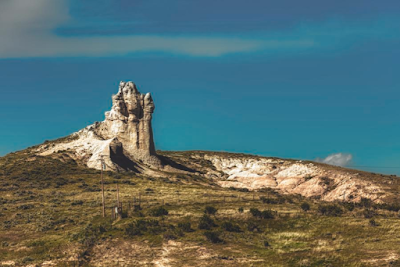
Significance: It looks cool.  It's actually dried magma (igneous rock) - which has "risen" as the rock around it has eroded away.  It will continue to do this, so it will become larger (or more of it will be exposed) as the "floor" lowers.  It was a big part of the movie "Close Encounters of the Third Kind."  And it's a popular place for rock climbing.  The name came from a misinterpretation of the Native American name for it. It was thought they called it "bad god tower." But they actually called it "Bear Lodge Butte" after a story that the marks on the sides were from a large bear trying to climb it.

Website: National Park Service


Image:

Devils Tower (from nps.gov)

Monday, August 17, 2020

Teapot Dome Historical Oilfield, WY

 Place: Teapot Dome Historical Oilfield

Weather: Mostly sunny skies, 59/95F.

Route: From Sioux Falls 579 miles west on I-90 W and WY-50 S.

Significance: Albert Fall was the first cabinet official to ever face a prison sentence in U.S. history as part of the Teapot Dome scandal.  He was the Secretary of the Interior for Warren Harding in the early from 1921-23.  Teapot Dome was the name of one of three oilfields - the others were in California - that Fall leased to oil companies without any competitive bidding process. In return he received over 7 million dollars (in today's money) in no interest loans and outright bribes.  Harding's administration was pretty corrupt - he brought many of his old friends from Ohio into his administration - they became known as the "Ohio gang." 


Image:


Teapot Rock (from fineartamerica.com)

Sunday, August 16, 2020

Sioux Falls, SD

 Place: Sioux Falls, SD

Weather: Sunny skies, 57/84F

Route: From Pipestone National Monument 49 miles SW on MN-23 W and I-90 W.

Population: 183,793 (2019)

Nicknames: Best Little City in America, Queen City of the West, The Heart of America.

Places to visit: Falls Park, Butterfly House & Aquarium, Old Courthouse Museum, Sioux Empire Medical Museum.


Images:

Falls Park and downtown in background (from travelsouthdakota.com)

The Arc of Dreams (from siouxfalls.org)

Saturday, August 15, 2020

Pipestone National Monument, MN

 Place: Pipestone National Monument, MN

Weather: Mix of clouds and sun with chance of isolated thunderstorms in afternoon, 57/76F.

Route: From Minneapolis 198 miles WSW on MN-65 S, US-212 W, MN-19 W, MN-23 W.

Significance: The red stone quarry here supplied many tribes with stone used for their pipes.  These pipes were and are used in spiritual ceremonies - the smoke is thought to go to the heavens. Native Americans from all over the plains still come to harvest the stone. It is a deeply spiritual place.  Below is a 20 minute video that explains more.


Website: National Park Service

Video:

Pipestone: An Unbroken Legacy

Images: 

The quarry (from nationalparks.org)

Ceremonial pipe made from pipestone from the quarry (from mprnews.org)

Friday, August 14, 2020

Minneapolis, MN

 Place: Minneapolis, MN

Weather: Isolated thunderstorms, 68/81F

Route: From Fargo 235 miles SE on I-94 S. 

Population: 429,606 (2019)

Images:

Downtown (from hftp.com)

Minneapolis Sculpture Garden (from minneapolis.org)